Tocht Mountainbike La Capelle-Balaguier - VTT La Capelle 31km 750D+(Mag, Chris, Didier,Pascal) 2021-11-16 - Photo

VTT La Capelle 31km 750D+(Mag, Chris, Didier,Pascal) 2021-11-16

© OpenStreetMap contributors
Lengte
Lengte
31 km
Max. hoogte
Max. hoogte
397 m
Positief hoogteverschil
629 m
Km-Effort
Km-Effort  
39 km
Min. hoogte
Min. hoogte
178 m
Negatief hoogteverschil
628 m
Boucle
Boucle
Ja
Datum van aanmaak :
2021-12-23 11:38:52.328
Laatste wijziging :
2021-12-23 11:41:32.221

(0 Bericht)

Mountainbike
Mountainbike
2h43
Moeilijkheid : Gemakkelijk

Scan deze QR-code om de tocht te openen in de SityTrail-applicatie

Gratisgps-wandelapplicatie

Logo SityTrail SityTrail

IGN / Geografische instituten

SityTrail uit de App Store downloaden SityTrail uit Google Play downloaden

Logo SityTrail SityTrail World

De wereld gaat voor u open

SityTrail uit de App Store downloaden SityTrail uit Google Play downloaden SityTrail op Huawei AppGallery downloaden

Over ons

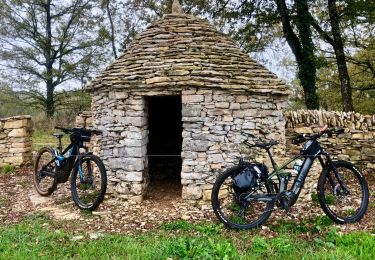
Tocht Mountainbike van 31 km beschikbaar op Occitanië, Aveyron, La Capelle-Balaguier. Deze tocht wordt voorgesteld door Levillefranchois.

Beschrijving

Parking du centre du bourg.
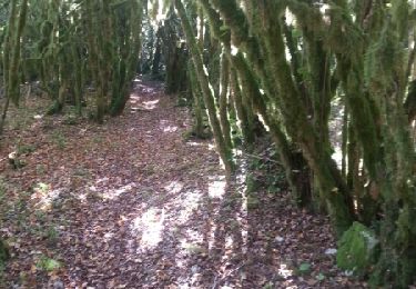
De beaux sentiers entre des buis moussus.
Techniquement facile.

Hoogteprofiel

Plaatsbepaling

Land:
France
Regio :
Occitanië
Departement/Provincie :
Aveyron
Gemeente :
La Capelle-Balaguier
Locatie:
Unknown
Vertrek:(Dec)
Vertrek:(UTM)
415376 ; 4920939 (31T) N.

Wandeltochten in de omgeving

Tocht Te voet Sainte-Croix - Balade autour de Sainte-Croix - Circuit 1 - Photo
Te voet
PRO

Te voet

Gemakkelijk
Sainte-Croix, Occitanië, Aveyron, France
4,2 km | 5,3 km-effort
1h 12min
Ja
Tocht Te voet Sainte-Croix - Balade autour de Sainte-Croix - Circuit 2 - Photo
Te voet
PRO

Te voet

Gemakkelijk
Sainte-Croix, Occitanië, Aveyron, France
4,9 km | 6,2 km-effort
1h 24min
Neen
Tocht Te voet Sainte-Croix - Balade autour de Sainte-Croix - Circuit 3 - Photo
Te voet
PRO

Te voet

Gemakkelijk
Sainte-Croix, Occitanië, Aveyron, France
6,5 km | 8,1 km-effort
1h 50min
Ja
Tocht Te voet Sainte-Croix - Circuit des 3 clochers - Photo
Te voet
PRO

Te voet

Gemakkelijk
Sainte-Croix, Occitanië, Aveyron, France
13,9 km | 17,4 km-effort
3h 57min
Ja
Tocht Mountainbike La Capelle-Balaguier - la capelle maroule puyjourdes loule anglars les buis lacapelle - Photo
Mountainbike
Gerard_Soulie

Mountainbike

Medium
La Capelle-Balaguier, Occitanië, Aveyron, France
31 km | 40 km-effort
2h 52min
Ja
Tocht Mountainbike La Capelle-Balaguier - la capelle anglars estrabols borieangle croix belge saut mounine trep et retour lac - Photo
Mountainbike
Gerard_Soulie

Mountainbike

Medium
La Capelle-Balaguier, Occitanië, Aveyron, France
32 km | 40 km-effort
3h 8min
Ja
Tocht Stappen La Capelle-Balaguier - Boucle de Lacapelle Balaguier - Photo
Stappen
tracegps

Stappen

Medium
La Capelle-Balaguier, Occitanië, Aveyron, France
14 km | 18,4 km-effort
3h 0min
Ja
Tocht Stappen Martiel - Boucle des dolmens de Martiel - Photo
Stappen
tracegps

Stappen

Medium
(1)
Martiel, Occitanië, Aveyron, France
9,4 km | 11,2 km-effort
2h 0min
Ja
Tocht Mountainbike Sainte-Croix - VTT Ste Croix 18km 400D+ 2023-09-16 - Photo
Mountainbike
Levillefranchois

Mountainbike

Gemakkelijk
Sainte-Croix, Occitanië, Aveyron, France
18,4 km | 23 km-effort
1h 35min
Ja


Sluiten
Mijn abonnementen